
What caused the deadly Baybay landslides? My take as a soil scientist.
- Details
- Written by Professor Victor B. Asio, PhD
-
Published: 21 April 2022
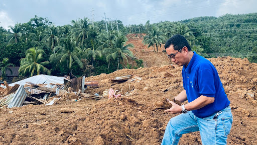
The researcher visited ground zero in Barangay Bunga, Baybay City, Leyte which is one of the communities covered by a landslide. In this community alone, around 8 households were buried killing a total of 17 people.
(Editor’s Note: Dr. Asio, a full professor of soil science and geo-ecology at Visayas State University, is one of the top soil scientists in the Philippines. He is also the Dean of the VSU College of Agriculture and Food Science and the Editor-in-Chief of the Annals of Tropical Research, the university’s international, peer-reviewed journal.)
With the coming of Tropical Storm (TS) Agaton, deadly landslides occurred in several barangays in Baybay City: in Brgy. Kantagnos, Brgy. Bunga, and Brgy. Mailhi. As of today, 175 are dead and 110 are still missing. Baybay City has been put under a state of calamity.
It’s easy to pin the blame on deforestation or shallow rooted plants like coconut; this I’ve seen on social media. As a soil scientist, I’d like to provide a more nuanced, research-based perspective to what happened.
Here’s my take: There are several and combined factors that caused these landslides to happen. The most important to consider are: geology, topography, soil characteristics, land use and vegetation cover, as well as, rainfall.
Geology
If you notice, the landslides in Baybay happened in the western slopes of the central highlands of Leyte. We call this the Leyte Cordillera. This mountain range is volcanic, and consists mainly of pyroclastic rocks (specifically basalt and andesite), which are generally fragmented rocks produced by volcanic eruptions.
Consequently, the slopes that serve as “foundation” to these materials are weak and fickle. This is further aggravated by the presence of the Philippine fault line along the central highlands, which has caused the shearing of the rocks.
With the unstable geology, exposure to heavy rainfalls, strong winds, earthquakes and many more, such land structure can easily crumble.
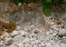
The common type of pyroclastic rocks in the central highlands of Leyte.
Topography
The western slope of the central highlands is generally rugged and mountainous. The steepness of a mountain slope is a major determining factor whether the slope will fail or not.
The steeper the slope, the less stable it is. In the presence of a triggering factor such as a heavy rainfall event, steep slopes (>25%) may fail, thereby causing landslides. From the topographic maps available online, one can easily see that the source areas of the Baybay landslides have steep slopes.
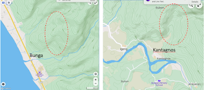
Topographic maps show the steep slopes of the source areas of Bunga & Kantagnos landslides
Soil
Soils in the mountain vary in stages of development from young (poorly weathered) to old (highly weathered) soils.
Young, absorbent or porous, and unstable volcanic soils (65% porosity) are prone to landslides, and are widespread in the upper mountain slopes, generally above 300 meters elevation. This was the case in Brgy. Mailhi.
Most of the Baybay landslides occurred on old and highly weathered soils. These soils are quick to crumble, moist or clayey, and prone to shallow landslides. When saturated with water, the clay serves as a lubricant for the sliding mixture of soil and rock debris.
Now, regardless of soil type, any soil can turn into a liquid state when supersaturated with water resulting in mudslides.
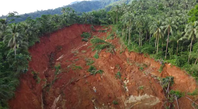
The source area of the Bunga landslide with its highly weathered soil, deep-seated characteristic, and mixed vegetation cover. (Photo Source: jbatravelvlog)
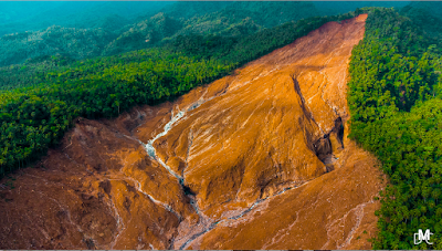
The source area of the deep-seated Kantagnos landslide with its highly weathered soil and relatively thick mixed vegetation. (Photo Source: Dan Michael Castanares)

The deep Mailhi landslide with its unstable young volcanic soil and mixed vegetation cover. (Photo Source: jbatravelvlog)
Land Use
Vegetation cover, particularly trees, can prevent soil erosion and shallow landslides, which generally occurs within the root zone. No doubt, forest trees can minimize shallow landslides better than shallow-rooted plants like coconut and grasses like cogon.
Studies have revealed that roots increase water permeability and the mechanical stability of shallow pyroclastic soil cover (Alfonso-Dias, 2019), meaning the roots helped the soil absorb water better and made it more stable. Zhang et al. (2019) found that the 23-year-old reforest in the mountain in Tacloban, Leyte, positively affected the hillslope hydrological functioning.
However, deep landslides that occur below the root zone are beyond the control of the roots of the vegetation cover (Zhuang et al., 2022). In such a case, the failure of the land surface is controlled more by the steep slope and by the weak geological and soil foundation. This explains why landslides can occur under any type of vegetation cover or land use.
For example, on a clear day, one can see several old landslide scars in the forest on Mt. Pangasugan. In the Bunga and Kantagnos landslides, the largest Baybay landslides, the source area in the upper part of the mountain is still covered with mixed vegetation consisting of trees and coconuts. According to Forbes and Broadhead (2013), the forest cover will not affect the occurrence of landslides during extreme events such as heavy rainfall.
In simple terms, landslides can still happen even without deforestation with the right conditions in the soul beyond tree roots.
Rainfall
Excessive soil water content from heavy rainfall is generally considered the primary cause of slope failure (Forbes and Broadhead, 2013).
Agaton poured in a tremendous volume of rain from April 9 to 11—a whopping 907mm—which is one-third of the annual rainfall in Baybay (Source: VSU-PAGASA Agromet Station). That’s about four months of rain in three days!
That’s water waist-high when poured into the land surface of Baybay. This volume of water is equivalent to 9,000 cubic meters of water per hectare or about 200 gallons per square meter.
No vegetation type can absorb and evaporate this tremendous amount of water in so short a time. Likewise, no soil can either hold or percolate this volume of water in just two days. Even the very porous young volcanic soil in Mailhi, which has an average porosity of 65% and moisture content at a field capacity of 40%, can only potentially absorb 58 gallons of water per square meter calculated to a depth of 1 meter.
The old soil under the forest can potentially hold a maximum of only 61 gallons per square meter to a depth of 1 meter. The old soil under coconut can hold only 55 gallons per square meter. The rainwater we had was three to four times more than that.
These values are even based on the assumption of a flat surface and fast infiltration rates, which is not the case in those landslide areas. This means that the actual amount of water that the soils on the mountain slopes can hold is much lower than the values mentioned.
As soon as the soil is saturated with water, the incoming rainwater cannot be accommodated in the soil pores and flows as surface runoff, causing the landslides, and notably the flooding, for the first time in about four decades in the city center of Baybay.
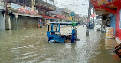
Severe flooding of the city center of Baybay due to Agaton on April 10, 2022. This is the first severe flooding of Baybay that I have witnessed in nearly four decades. (Photo Source: Discover Baybay City).
Conclusion
In conclusion, the Baybay landslides were triggered by the extremely heavy rainfall and enhanced by the unstable and highly weathered soils (or the young unstable volcanic soil in the case of Mailhi), weak geologic material composed of pyroclastic rocks, and the steep slopes.
Trees and plants can only do so much, since it can partly prevent shallow landslides, but not deep-seated landslides such as those in Bunga, Kantagnos, and Mailhi. This means that the coconut's shallow root system (about a meter deep) may not have effectively prevented the landslides, but the same can be said of the trees with their 2-3 meter deep rooting zone since the landslides are several meters deep in their source areas.
Landslides are natural geologic processes on the land surface. Catastrophic landslides like those we have witnessed recently in Baybay may occur again anytime at any place with the above environmental conditions regardless of the vegetation cover.
I suspect that several incipient landslides (landslides in the initial stage) were produced in various areas during Agaton but are hidden by the vegetation cover. Another storm or typhoon may trigger these landslide incidents to become full or even catastrophic landslides.
Thus, it is crucial that residents living in landslide-prone areas be given proper and timely attention.
[This article is republished from Dr. Asio’s blog and edited with permission.]